What is Ultimaps?
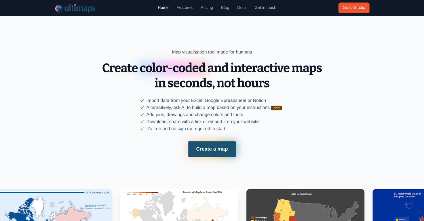
Ultimaps is a map visualization tool designed for easy and efficient creation of color-coded and interactive maps. The tool allows users to import data from a variety of sources like Excel, Google Spreadsheet or Notion to personalize and build maps. It supports a range of customization features, enabling users to add pins, drawings, and adjust colors and fonts to suit their needs. Maps created with Ultimaps can be made interactive using elements like tooltips and popup windows and can be shared or embedded on a website. Ultimaps works seamlessly on mobile devices and provides autosave functionality, and offers both a free and a subscription-based Pro version.
How does Ultimaps work with data import from various sources like Excel and Google Spreadsheet?
Ultimaps allows users to import data directly from Excel, Google Spreadsheet, or Notion. Data imported into Ultimaps is then used to build maps, which are then automatically color-coded based on the data. This process allows users to visually represent their data in an interactive, dynamic format.
What customization features are available in Ultimaps?
In Ultimaps, users have access to a range of customization features. These include the ability to adjust color schemes, add pins to indicate particular locations of interest, add drawings to enhance storytelling and engagement, and changing fonts to meet specific needs.
How can I add pins and drawings on my Ultimaps?
Adding pins and drawings in Ultimaps is facilitated by the platform's customization features. Users can place pins at specific locations to highlight areas of interest. Additionally, they can add drawings such as text, lines, and rectangles to their maps to enhance the visual appeal and provide added context or commentary to their mapping data.
How can Ultimaps maps be shared or embedded on a website?
Maps produced using Ultimaps can be easily shared or embedded on a website. After creating a map, users can publish it and share it via a link. Additionally, Ultimaps provides embed codes that allow users to insert their maps directly into a webpage, making it accessible and viewable from their own website.
Is Ultimaps compatible with mobile devices?
Yes, Ultimaps is compatible with mobile devices. This ensures that maps can be viewed and interacted with seamlessly, regardless of the device being used. This makes the tool versatile and user-friendly, permitting map access and interaction anytime, anywhere.
Does Ultimaps offer autosave functionality?
Yes, Ultimaps offers an auto-save feature. This ensures that all map visualizations are saved automatically, allowing users to return to their work whenever required without fear of losing progress. This makes map creation a stress-free process as there's no risk of losing work due to unsaved changes.
What is the difference between the free tier and Pro version of Ultimaps?
The free tier and Pro version of Ultimaps provide different feature sets to meet varying user requirements. The free version includes unlimited maps, export to PNG format, storage of maps in the user account, and mandatory attribution. The Pro version, meant for regular map publishers or those needing a white-label version, offers additional features like no attribution required, export to SVG and for printing, unlimited embeds, and priority email support.
How can I make my map interactive using Ultimaps?
To make a map interactive using Ultimaps, users can use elements like tooltips and popup windows. These tools make the map more dynamic, as they can provide additional details about a location or point of interest when a viewer hovers over or clicks on it.
What types of data can be visualized using Ultimaps?
Ultimaps allows users to visualize numerical data, categorical data, sales territory data, and presence data. This provision makes the tool adaptable to a wide range of data visualization tasks.
Can you explain the map personalization features and capabilities of Ultimaps?
Map personalization in Ultimaps involves a suite of features that allow users to tailor map appearance to their needs. These features include adjusting color schemes, adding pins to highlight specific locations, and adding drawings like text, lines, and rectangles to improve storytelling. The tool also allows users to change fonts, ensuring that the map is not just informative but also aligns with the user's aesthetic preferences.
What kind of white-label provisions do the subscription plans of Ultimaps offer?
The Pro version of Ultimaps provides white-label provisions for users. This means that Pro users can publish and share their maps without any Ultimaps branding, allowing for a seamless integration into branded materials or presentations.
Can I adjust legends in Ultimaps?
Yes, in Ultimaps, each map comes with an adjustable legend. The automatic color-coding feature populates the legend based on imported data, and users have the ability to adjust this legend as needed, offering flexibility in data representation.
How user-friendly is Ultimaps for new users with no specific knowledge?
Ultimaps is built to be user-friendly and requires no specific prior knowledge from users. The tool guides users through the process of importing their data, visualizing it on a map, and customizing the map to their liking. Furthermore, no sign-up is required to use the free tier of the service, allowing anyone to start creating maps immediately.
How do tooltips and popup windows enhance map interactivity in Ultimaps?
Tooltips and popup windows in Ultimaps enhance the interactivity of the maps. These elements can disclose more information about a location when a viewer interacts with it, such as by hovering over or clicking on a specific point. This results in a more engaging and informative map, allowing audiences to explore the map's data in a more hands-on way.
What are the benefits of the auto-saving feature in Ultimaps?
The auto-saving feature in Ultimaps is beneficial as it ensures that all map creations are automatically saved. This provides users with peace of mind knowing that their work is being constantly saved, reducing the risk of losing progress due to unsaved changes. It also allows users to step away from their work and return to it later, as everything will be as they left it.
Is there a limit on the number of maps I can create with Ultimaps?
With Ultimaps, users can create as many maps as they want. There are no map creation limits, enabling users to explore and visualize different datasets freely.

 Transform static images into interactive clickable maps.Open


How would you rate Ultimaps?
Help other people by letting them know if this AI was useful.