Go to section
Spotlight![]() SureThing.io - "OpenClaw" for BeginnersTask automation
SureThing.io - "OpenClaw" for BeginnersTask automation
The front page of AI.Used by 90M+ humans.

TAAFT Tutorial
Generate image
Tasks
Generate text
Free mode
Trending
Leaderboard
Characters
 Mini tools
New
Featured
Lists
Agents
Requests
Jobs
Map
Newsletter
Starter pack
Free tools
Speech to text
Text translator
Remove background
Settings
Edit profile
My tools
Gallery
Dashboard
Inbox
Get featured
Contact TAAFT
For you
Popular
Job impact index
Most saved
Affiliate program
Submit AI tool
Notification preferences
Glossary
Home
Timeline
My profile
Create tool
Deals
Companies
Models
Robots
Papers
Fundraises
Repositories
Devices
Organizations
Events
Prompt Pack
Merchendise
APIs
Features
Tools
Countries
Collections
Videos
Mini tools
New
Featured
Lists
Agents
Requests
Jobs
Map
Newsletter
Starter pack
Free tools
Speech to text
Text translator
Remove background
Settings
Edit profile
My tools
Gallery
Dashboard
Inbox
Get featured
Contact TAAFT
For you
Popular
Job impact index
Most saved
Affiliate program
Submit AI tool
Notification preferences
Glossary
Home
Timeline
My profile
Create tool
Deals
Companies
Models
Robots
Papers
Fundraises
Repositories
Devices
Organizations
Events
Prompt Pack
Merchendise
APIs
Features
Tools
Countries
Collections
Videos
▼ Latest
Geojson
Free mode
100% free
Freemium
Free Trial
Featured matches
-
-

-

-
-

-
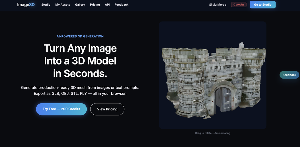 刘中奎🙏 1 karmaMay 12, 2026@Image3D.ioImage3D feels like a practical tool rather than just a demo. The workflow is simple, the preview loads in-browser, and I can export common formats like GLB, OBJ, STL, and PLY. I would recommend it for fast 3D asset drafts and 3D printing experiments.
 -
 Didn't even get the country right. The place looked nothing like the location on my image. :/


Verified tools
-
Eh it's ok. You only get one question to test it out and the quality of the info you get in that one message is too lackluster to warrant going back for more, especially if you're into astrology and already know basic stuff. The aesthetic is fine. Some of the buttons are inexplicably disabled and the tooltips conflict with one another on the map, making it irritating to try to interact with the lines rendered on the map.
-
This thing is actually insane. I uploaded a picture from a random hike I did years ago, and it guessed the location exactly. Not just the country but the exact trail. I have no idea how it works, but its pretty impressive.
- Spotlight
 SureThing.io - "OpenClaw" for BeginnersTask automation


Other tools
-
was good but no longer accessible in there own words "available exclusively to qualified law enforcement agencies, enterprise users and government entities"
-
Google Earth AI embraces a plethora of tasks. It helps in visualizing geographic data, guides in making advanced data mapping, and supports in 3D earth modeling. It also provides a platform for location-based services and remote sensing, while incorporating satellite imagery for detailed geospatial analysis.
-
- Didn't find the AI you were looking for?
-
I tried other tools aswell, this was the only accurate. Other ais didn't even get the country right. Compared to the others it had the advantage that I could specify the area in which the location was. I only tried it once so far but I am satisfied.
-
-


