
TAAFT Tutorial
Generate image
Tasks
Generate text
Free mode
Trending
Leaderboard
Characters
 Mini tools
New
Featured
Lists
Agents
Requests
Jobs
Map
Newsletter
Starter pack
Free tools
Speech to text
Text translator
Remove background
Settings
Edit profile
My tools
Gallery
Dashboard
Inbox
Get featured
Contact TAAFT
For you
Popular
Job impact index
Most saved
Affiliate program
Submit AI tool
Notification preferences
Glossary
Home
Timeline
My profile
Create tool
Deals
Companies
Models
Robots
Papers
Fundraises
Repositories
Devices
Organizations
Events
Prompt Pack
Merchendise
APIs
Features
Tools
Countries
Collections
Videos
Mini tools
New
Featured
Lists
Agents
Requests
Jobs
Map
Newsletter
Starter pack
Free tools
Speech to text
Text translator
Remove background
Settings
Edit profile
My tools
Gallery
Dashboard
Inbox
Get featured
Contact TAAFT
For you
Popular
Job impact index
Most saved
Affiliate program
Submit AI tool
Notification preferences
Glossary
Home
Timeline
My profile
Create tool
Deals
Companies
Models
Robots
Papers
Fundraises
Repositories
Devices
Organizations
Events
Prompt Pack
Merchendise
APIs
Features
Tools
Countries
Collections
Videos

▼ Latest
Environmentalist
Free mode
100% free
Freemium
Free Trial
Featured matches
-
-
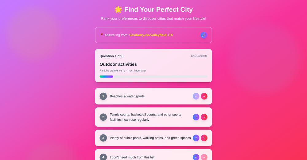
 Marco Patuzzo🛠️ 2 tools 🙏 50 karmaSep 10, 2025@bestcity.ioThis tool feels like a tiny coach for places. Rank what matters to you (parks, beaches, sport courts, or "don't need much") across a quick 8 question flow and it points you toward cities that match your vibe. Not bad at all
 -

Verified tools
-
Great idea, but does not find what you are looking for-about the same as Google Scholar
-
Looks very unseful. I'd really like to read a tailored newsfeed without overwhelming me with unnecessary news. Well done.


Other tools
-
 AI-accelerated climate digital twin for global weather simulation.Open
 - Sponsor
 Tripo AI 3D Generator
 -
After not even ONE try, it asks for Pro. No success, just imo developer hyper-greed. Avoid!
-
 Open
Open - Didn't find the AI you were looking for?
-
-
tested it on a few neighborhoods. the interface is so stripped down it almost feels unfinished, quick to load but u might hunt for extra fillers. the data look on point, yet they dont dive deep into data sources to explain. overall accuracy feeks solid and the map is smooth, just wish it talked more about the results.
-
Google Earth AI embraces a plethora of tasks. It helps in visualizing geographic data, guides in making advanced data mapping, and supports in 3D earth modeling. It also provides a platform for location-based services and remote sensing, while incorporating satellite imagery for detailed geospatial analysis.
-


