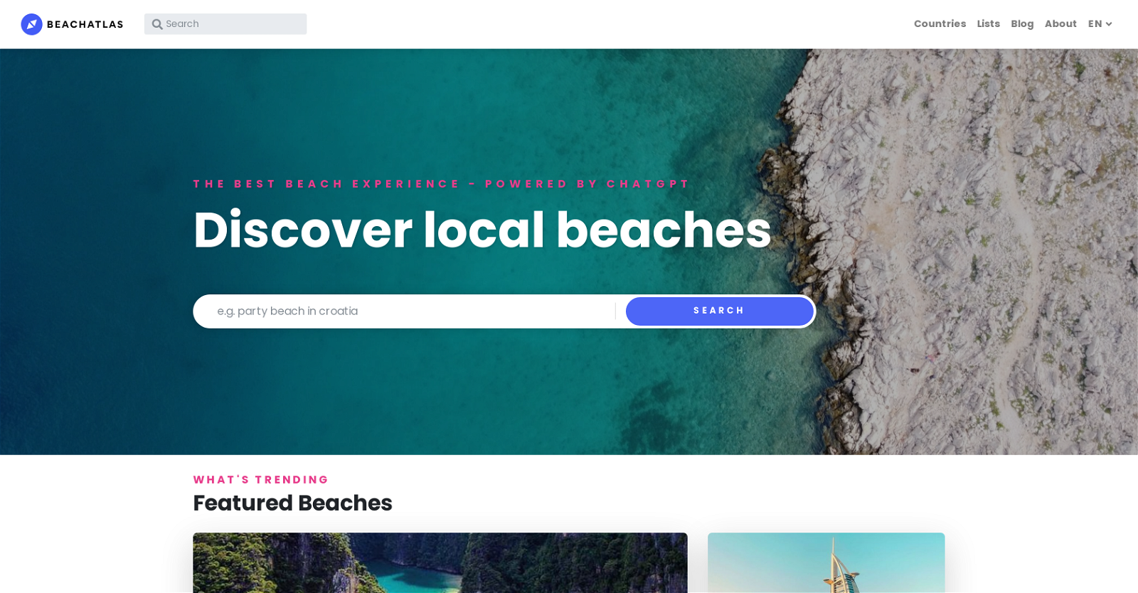
What is BeachAtlas?
BeachAtlas is an AI-based tool designed for beach enthusiasts worldwide. It assists users in discovering and exploring multiple local beaches, making the beach exploration process seamless, interesting, and efficient.
How does BeachAtlas work?
BeachAtlas works by utilizing various AI-based functionalities represented by different icons. These icons guide users in finding beach-related services, planning travel times, and even understanding costs associated with various activities. It conveniently presents essential information and supports various forms of user interaction.
What kind of features does BeachAtlas offer?
BeachAtlas provides an array of features. This includes beach exploration, local discovery, travel planning and traffic awareness, interactive mapping for navigation, customer support, and sailing information. It helps to locate features such as restaurants and swimming pools, displays associated costs, and finds other points of interest like hospitals and shopping centers.
What is the purpose of different icons in BeachAtlas?
The various icons in BeachAtlas represent different functionalities that enhance the user's experience. These icons are associated with customer support, sailing information, restaurant and swimming pool locators, amongst others. They also include travel time estimation tools, payment options, and comfort-enhancing features like Alarm Clock and Vintage Camera.
How do I plan my travel times using BeachAtlas?
Travel times can be planned by utilizing the Interactive Navigation Map and the 'Delivery time' icon within BeachAtlas. These features allow users to plan their journey's duration to their chosen beach destination effectively.
Can I find costs of different activities on BeachAtlas?
Yes, BeachAtlas allows users to find the costs associated with different activities and services. This information is represented through the Dollar Sign, Pay by Card, and Money icons.
Can I discover places other than beaches using BeachAtlas?
Yes, BeachAtlas caters to more than just beaches, allowing users to discover other points of interest such as hospitals, shopping centers, and more. These locations can be quickly identified through the smartly integrated AI features and interactive maps provided by the tool.
Does BeachAtlas offer any recommendations for local beaches?
BeachAtlas does offer recommendations for local beaches. The tool is designed to uncover the beauty of local beaches, making it easier for beach enthusiasts to find and explore them.
How do I navigate to my chosen beach destination using BeachAtlas?
BeachAtlas provides an interactive navigation map, destination map, and compass map to help users effectively navigate and explore their chosen beach destination.
Can I find information about beach-related activities on BeachAtlas?
Yes, BeachAtlas provides key information about different beach-related activities and services. Options such as sailing, and tools like the restaurant and swimming pool locators, provide users with in-depth insights about their chosen beach location.
Does BeachAtlas have a customer support feature?
Yes, BeachAtlas has a customer support feature. The Customer Support icon and tools like Live Chat efficiently help users with any queries or issues they may have while using the platform.
How do I find a swimming pool or restaurants using BeachAtlas?
Using the restaurant and swimming pool locator icons, users can quickly find nearby restaurants and swimming pools in their chosen beach area.
What other points of interest can BeachAtlas help me discover?
BeachAtlas can help users discover various points of interest. Apart from beaches, other locations including hospitals, shopping centers, and more can be located using BeachAtlas's navigation tools.
Is BeachAtlas useful for sailing information?
Yes, BeachAtlas provides sailing information. The Sailing icon offers key insights into sailing-related activities for beach enthusiasts.
What other user convenience features are included in BeachAtlas?
BeachAtlas incorporates numerous features geared towards enhancing the user's comfort and ease. This includes the Alarm Clock icon for reminders, the Vintage Camera for photography enthusiasts, and more.
Can I use BeachAtlas for travel planning?
Yes, users can use BeachAtlas for travel planning. The tool provides an array of planning aids, such as travel time estimation, destination mapping, and cost assessment of different services and activities.
What kind of local discovery options are available in BeachAtlas?
BeachAtlas supports local discovery in multiple ways. Users can find beaches, restaurants, swimming pools, and other points of interest like hospitals and shopping centers in their local area.
Does BeachAtlas support multiple languages?
Yes, BeachAtlas supports multiple languages. The website has options to switch to different languages including English, French, German, Italian, Dutch, Portuguese, Russian, and more.
What kind of user interactions does BeachAtlas support?
BeachAtlas supports user-oriented interactions through a variety of means. This includes a landline and smartphone tool, chat app, and paper plane tool for communications and queries.
What kind of mapping options are available in BeachAtlas?
Mapping options in BeachAtlas include an interactive navigation map, destination map, and compass map, all of which assist in effectively locating and exploring destinations.
 15,257