What industries does Picterra serve?
Picterra serves various industries including Forestry and Carbon Markets, Agriculture and Regenerative Farming, Mining and Quarries, Infrastructure, and FMCG & commodities.
How does Picterra use AI for geospatial solutions?
Picterra uses AI to provide geospatial solutions in several ways. It incorporates AI technology for object detection, change monitoring, and pattern discovery, which collectively aim to optimize geospatial workflows.
What are the specific functionalities Picterra provides for different industries?
Picterra offers specific functionalities for different industries. For Forestry and Carbon Markets, it uses AI for tree detection. For Agriculture and Regenerative Farming, it provides multi-class crop detection. And for the Mining and Quarries sector, it provides mine expansion and deforestation detection.
How does Picterra facilitate quick action?
Picterra facilitates quick action by offering features like object detection, change monitoring and pattern discovery. These features optimize geospatial workflows, thereby enabling businesses to quickly analyze their data and implement necessary actions promptly.
How does Picterra automate data analysis?
Picterra provides a platform where customers can automate their data analysis. By leveraging AI technology for object detection, change monitoring and pattern discovery, Picterra allows businesses to generate insights effectively and efficiently.
What features does Picterra provide for the Forestry and Carbon Markets?
For the Forestry and Carbon Markets, Picterra provides tree detection functionality. This makes it possible to accurately monitor and analyze the forest area in an automated way, which can be critical in maintaining forest health and implementing environmental conservation measures.
What solutions does Picterra offer for Agriculture and Regenerative Farming?
In the Agriculture and Regenerative Farming sector, Picterra offers multi-class crop detection. This functionality allows for enhanced analysis and understanding of various crops, promoting efficient farming practices and contributing to sustainable agriculture.
What are the functionalities provided by Picterra for Mining and Quarries?
For the Mining and Quarries sector, Picterra provides functionalities for mine expansion and deforestation detection. These features enable businesses to monitor changes in geographical areas around mines and quarries, helping them maintain environmental and operational standards.
What solutions does Picterra offer regarding EUDR compliance?
Picterra extends its services to providing professional solutions that adhere to EUDR compliance. While the specifics of these solutions aren't outlined on the website, they likely involve ensuring that geospatial data handling and analysis align with the requirements of the European Union Drone Regulation.
How can Picterra help in pattern discovery?
Picterra's AI technology supports pattern discovery in geospatial data. This feature enables the detection of recurring or significant patterns in data, which can offer valuable insights and opportunities for business improvements.
Can Picterra detect changes and monitor them over time?
Yes, Picterra provides change monitoring functionality. This feature, powered by AI, allows users to track alterations in geospatial data over time, offering critical insights for decision-making and action plans.
Does Picterra have a free trial offer?
Yes, Picterra does offer a free trial. Businesses can try the Picterra platform for 14 days for free.
What professional services does Picterra provide?
Picterra provides various professional services including Imagery Sourcing and Processing, Detector Training Support, Change Detection, Tracking & Monitoring, and Dashboard & Results Customization. These services aim to assist businesses in fully utilizing the Picterra platform for their specific needs.
How does Picterra help businesses interpret data more effectively?
Picterra helps businesses interpret their data more effectively by providing a platform that uses AI for detailed and accurate geospatial analysis. This approach enables businesses to derive meaningful insights from their data and guides informed decision-making.
Does Picterra offer any specific solutions for FMCG & commodities sector?
Picterra does offer solutions for the FMCG & Commodities sector. However, the specifics of these solutions aren't provided on their website.
What is meant by 'geospatial workflows' in the context of Picterra?
Geospatial workflows in the context of Picterra likely involve the process of gathering, processing, and interpreting geospatial data. This could include processes such as data collection, object detection, change monitoring, and pattern discovery. Picterra's AI technology aims to optimize these workflows, bringing efficiency and accuracy to geospatial data analysis.
How does Picterra contribute to sustainability?
Picterra contributes to sustainability by providing AI-based geospatial solutions that enable businesses across various industries, including forestry, agriculture, and mining, to manage their data more effectively. It aims to drive sustainable action by helping these industries optimize their workflows, monitor changes, detect patterns, and make data-driven decisions that support environmental preservation and sustainability.
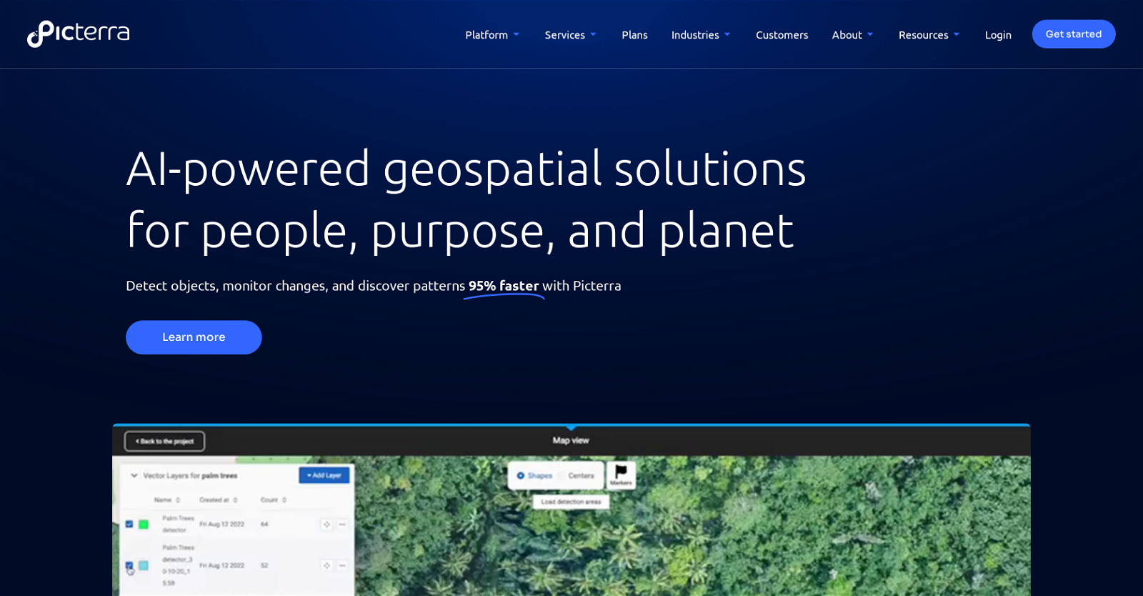
What is the Picterra platform?
The Picterra platform is a cloud-based platform that harnesses the power of AI for geospatial solutions. It offers features like object detection, change monitoring, and pattern discovery to optimize geospatial workflows.
Does Picterra provide interactive tours for understanding the platform?
Yes, Picterra does provide interactive tours where potential clients can learn how to use the platform and understand its features.
How is Picterra useful in the Infrastructure sector?
While specific solutions for the Infrastructure sector aren't expounded on their website, Picterra's overall offerings of object detection, change monitoring, and pattern discovery could enable infrastructure businesses to effectively monitor and analyze their geospatial data for efficient planning and maintenance.
 15,287