What is Archistar?
Archistar is an all-in-one property development tool formulated to optimize profit and minimize gamut of risks linked with property development.
How does Archistar help in property development?
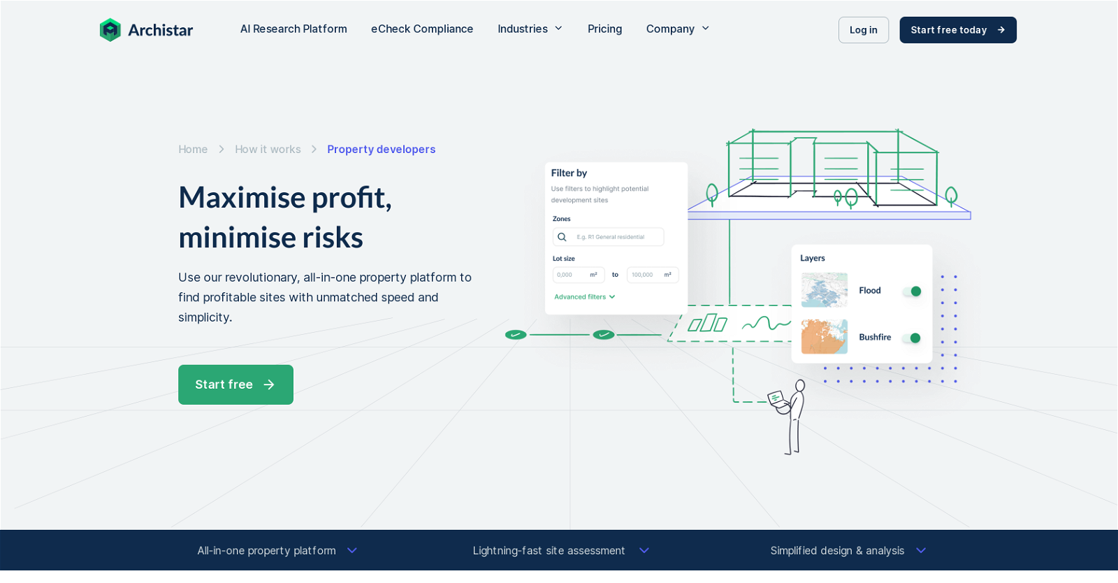
Archistar aids in property development by providing functions for swift site assessment, streamlined design and analysis, and risk limitation. Archistar consolidates pivotal planning rules from multiple sources, enabling users to comprehend aspects such as slope, bushfires, floods, transmission lines, heritage, and environmental layers impacting potential development sites.
How does Archistar minimize risks in property development?
Archistar minimizes risks in property development by providing a robust understanding of various site factors, useful planning rules from multiple sources, and information on property market. It also provides the ability to run static feasibility analysis on designs, assisting real estate professionals to make informed decisions before committing to projects.
What features does Archistar offer for fast site assessment?
For fast site assessment, Archistar provides lightning-fast site assessment tool, high-resolution aerial imagery, development potential tool, and an efficient dashboard to manage property portfolio. This suite of tools allows users to uncover sites with untapped residential and commercial development potential instantly and efficiently.
What is the design generator feature in Archistar?
Archistar's design generator is an AI-driven feature that can create hundreds of building designs, while adhering to site rules and restrictions. This tool allows users to envisage potential concepts early in the process where there's minimal risk.
How does Archistar's high-resolution aerial imagery feature work?
Archistar's high-resolution aerial imagery feature allows users to virtually survey a site instantaneously. This tool aids in identifying potential issues such as trees, undocumented construction, and other physical site characteristics.
Can Archistar help me understand market trends and local precedents?
Yes, Archistar helps in understanding market trends and local precedents. Powered by Domain, CoreLogic and BCI, Archistar provides information on the market trends, median prices, sold properties and even nearby developments, offering insight into local precedents which can influence development strategy.
What information does Archistar provide about potential development sites?
Archistar provides a wealth of information about potential development sites. This includes factors such as slope, floods, bushfires, transmission lines, heritage and environmental considerations. It also provides market data, median prices, and details on nearby developments. Additionally, Archistar’s high-resolution aerial imagery tool allows users to remotely survey the site and identify potential issues.
Who can use Archistar?
Archistar is suitable for both professionals and businesses involved in property development. This could include property developers, architects, builders, government and planners, enterprises, as well as real estate agents and property investors.
Can Archistar assist in portfolio management?
Yes, Archistar can assist in portfolio management with its efficient dashboard. The dashboard allows users to shortlist site opportunities and manage their portfolio all in one place. It simplifies the workflow and keeps track of site status right from research to acquisition.
Is Archistar helpful for real estate developers?
Yes, Archistar is extremely beneficial for real estate developers. With tools for site assessment, design generation, feasibility analysis, risk minimization, and understanding planning rules, Archistar empowers developers to maximize profits, minimize risks, and make informed investment decisions.
What is a due diligence report in Archistar?
In Archistar, a due diligence report is a comprehensive document prepared with a single click that assembles data related to property development. The report entails planning details, applicable layers, market details, suburb insights, nearby developments, generated designs, analysis on designs and feasibility on designs. It serves as a 'highest and best use' report, answering the question, 'How can I best use this piece of land?'.
Does Archistar help in design analysis and feasibility checks?
Yes, Archistar facilitates design analysis and feasibility checks. Users can pinpoint potential problems such as hours of sunlight and shadowing that could adversely impact the compliance of the development. Additionally, you can run static feasibility analysis on any designs to understand the potential return on investment.
How can Archistar help in understanding planning rules?
Archistar aids in understanding planning rules by consolidating the regulations from numerous sources. Over 25,000 planning rules sources are gathered into one place, allowing users to understand the maximum potential of their site and make informed financial decisions.
Does Archistar provide information on sold properties and nearby development?
Yes, Archistar provides information on sold properties and nearby developments. Information on the market, median prices, sold properties and even nearby developments are provided, thereby offering users insight into local precedents and market trends.
Can I use Archistar for risk assessment?
Yes, Archistar serves as an effective tool for risk assessment in property development. It consolidates key planning rules from numerous sources, allowing users to grasp factors like slope, bushfires, floods, transmission lines, and environmental layers that might impact potential development sites. It minimises risks by enabling users to be well-informed about these factors before proceeding with a project.
Does Archistar provide property market analysis?
Yes, Archistar provides comprehensive property market analysis. By partnering with Domain, CoreLogic, and BCI, Archistar users are privy to market information, median prices, sold properties, and even information on nearby developments. This holistic view of the market helps users make well-informed, financially sound decisions.
What is the development potential assessment tool in Archistar?
In Archistar, the development potential assessment tool is a unique technology that reveals sites with untapped residential development potential with just a few clicks. This tool drastically reduces time spent on finding optimal opportunities in a competitive market.
How does Archistar gather and present data?
Archistar gathers data directly from official government documents on a federal, state, and local level. It collects planning, zoning & permitted use data, standardizes, and catalogs the data to ensure it is presented to users in an understandable format. Along with this, it has affiliations with some of the best in the industry for market and development permit data which include Domain, CoreLogic, BCI, Cordell, and Nearmap.
What does Archistar's Platform offer for property developers?
The Archistar Platform for property developers provides numerous features like fast site assessment, design and analysis. This platform gathers planning rules from numerous sources and provides data about slope, bushfires, floods, transmission lines, heritage, and environment affecting potential development sites. It also provides a high-res aerial imagery feature for remote site survey. Market analysis, median prices, data on sold properties, and nearby developments are also provided by this platform. Moreover, it comes with a design generator that creates building options while respecting site rules and conducting static feasibility analysis on the designs.
 15,210